
Report Summary
At a cost of $2.2 billion, the Mid-Coast Trolley Extension is the largest single transit investment in San Diego’s history. It connects the University Community Plan area to the region’s existing Trolley network. After the opening of the new line, Trolley ridership saw an immediate jump, and ultimately Trolley ridership increased 52 percent from 2021 to 2022.
This investment is already generating economic activity, increased access to employment, and climate-friendly travel. San Diego could be getting even more.
Currently, land uses around the Mid-Coast Trolley Extension do not allow the highest and best uses. Zoning rules prohibit significant development of new homes, biotech laboratories, offices space, and neighborhood retail. Allowing new development would mean more economic growth, more homes, and more people riding the Trolley. San Diego should update its zoning rules to allow this growth.
In addition, local transportation infrastructure is insufficient to allow use of the Trolley. Many streets surrounding Trolley stations are unsafe for bicyclists and pedestrians. Buses that connect to Trolley stations are often stuck in traffic. An update to nearby transportation infrastructure would allow more people to access the Mid-Coast Trolley Extension by walking, bicycling, and taking the bus.
This report provides recommendations for how San Diego can make the most of the Mid-Coast Trolley Extension by:
- Increasing development capacity,
- Inviting voters to remove height limits where coastal views would not be impacted,
- Upgrading surface street corridors with dedicated rights-of-way for buses, bicycles, and pedestrians,
- Enhancing bus service and Trolley frequency,
- Transforming surplus government property into affordable homes,
- Retrofitting Mid-Coast Trolley Extension stations to increase access, and
- Implementing city-wide reforms to facilitate growth.
Some of these recommendations will require coordination between the San Diego Metropolitan Transit System, the San Diego Association of Governments, and the City of San Diego. The City has a near-term opportunity to make many of these changes through the update of the University Community Plan, which is already underway.
Following the recommendations in this report will allow the San Diego region to make the most of the Mid-Coast.
Presentations
On February, 23 2023 Circulate San Diego Policy Counsel, Jesse O’Sullivan, held a virtual Lunch and Learn on the report. Watch it here.
Press

-
The Guardian - Op-Ed: More Housing, For Us and Our Climate,
February 6, 2023 - Univision, 6 p.m. News – story starts at 0:45, February 14, 2023
- KSDY 50, Oportunidad de desarollo económico del tranvía en Ciudad Universitaria, February 14, 2023
- Televisa, Llegan Planes Para Conexión del Trolley,Febraury 14, 2023
- Times of San Diego, More Housing, Jobs in University City Seen Key to Success of Trolley Extension, February 14, 2023
- NBC 7, With San Diego’s Mid-Coast Trolley Extension Complete, Focus Turns to Economic Potential Along Route, February 14, 2023
- KUSI News, Circulate Mid-Coast Trolley Press Conference, February 14, 2023
- FOX 5 News at 6pm,February 14, 2023
- 600KOGO,The DeMaio Report With Carl DeMaio, February 14, 2023
- Report Press Conference with Congressman Scott Peters, February 14, 2023
- SDNews.com, Circulate San Diego releases report: Making the Most of the Mid-Coast Trolley, February 21, 2023
- University City News, Making the Most of the Mid-Coast Trolley, March 2023, page 5
- FY22 Report: MTS Ridership Climbs by Nearly 50%, MTS, August 16, 2022
- Bus Riders Deserve Better, Circulate San Diego, October 6, 2023
- Designing to Move People, National Associate of City Transportation Officials, March 21, 2023
- Capturing the Real Value of Transit-Oriented Development, California YIMBY, March 30, 2023
- Potential of high-density housing prompts debate in University City, Fox5, April 18, 2023
Making the Most of the Mid-Coast Trolley
- Read the mobile-first version of the report
- Visit Making the Most of the Mid-Coast Trolley’s main page
Associated Content for this Report:
Contents
- Executive Summary
- Introduction
- Making the Most of the Mid-Coast for Economic Growth, Equity, and the Climate
- The University Community Plan Update
- Bicycle, Pedestrian, and Bus Corridors
- Enhanced Transit Service
- Surplus Government Land
- Improved Mid-Coast Stations
- City-Wide Land Use Policies
- Other Land Use Updates
- Conclusion
- Acknowledgements
- Sponsors
- Endnotes
Executive Summary
At a cost of $2.2 billion,[1] the Mid-Coast Trolley Extension is the largest single transit investment in San Diego’s history. It connects the University Community Plan area to the region’s existing Trolley network. After the opening of the new line, Trolley ridership saw an immediate jump,[2] and ultimately Trolley ridership increased 52 percent from 2021 to 2022.[3]
This investment is already generating economic activity, increased access to employment, and climate-friendly travel. San Diego could be getting even more.
Currently, land uses around the Mid-Coast Trolley Extension do not allow the highest and best uses. Zoning rules prohibit significant development of new homes, biotech laboratories, offices space, and neighborhood retail. Allowing new development would mean more economic growth, more homes, and more people riding the Trolley. San Diego should update its zoning rules to allow this growth.
In addition, local transportation infrastructure is insufficient to allow use of the Trolley. Many streets surrounding Trolley stations are unsafe for bicyclists and pedestrians. Buses that connect to Trolley stations are often stuck in traffic. An update to nearby transportation infrastructure would allow more people to access the Mid-Coast Trolley Extension by walking, bicycling, and taking the bus.
This report provides recommendations for how San Diego can make the most of the Mid-Coast Trolley Extension by:
- Increasing development capacity,
- Inviting voters to remove height limits where coastal views would not be impacted,
- Upgrading surface street corridors with dedicated rights-of-way for buses, bicycles, and pedestrians,
- Enhancing bus service and Trolley frequency,
- Transforming surplus government property into affordable homes,
- Retrofitting Mid-Coast Trolley Extension stations to increase access, and
- Implementing city-wide reforms to facilitate growth.
Some of these recommendations will require coordination between the San Diego Metropolitan Transit System, the San Diego Association of Governments, and the City of San Diego. The City has a near-term opportunity to make many of these changes through the update of the University Community Plan, which is already underway.
Following the recommendations in this report will allow the San Diego region to make the most of the Mid-Coast.
The Mid-Coast Trolley Extension

Introduction
The Mid-Coast Trolley Extension (Mid-Coast) is the largest single transit investment in the history of the San Diego region. The project cost taxpayers $2.2 billion,[4] and connects the neighborhoods of Downtown and the University Community Plan area, two of the region’s primary employment centers. The project extended the existing Blue Line Trolley that runs from the San Ysidro border to Downtown, up through the I-5 corridor, to U.C. San Diego, curving eastward and terminating at the Westfield University Town Center mall. Even before the Mid-Coast extension, the Blue Line was one of the most successful light-rail lines in the United States.[5]
The project was most-recently approved by voters in the Transnet extension tax measure, adopted in 2004.[6] It only became a reality after decades of planning, and a $1 billion matching grant from the Federal government.[7]
The Mid-Coast is a major new transit connection to one of the region’s most economically important areas. The University Community Plan area includes U.C. San Diego, a world-class research institution and a major economic driver. The university is the second largest employer in the City of San Diego.[8] Many of its graduates begin their careers in our growing biotech sector, and work at local technology companies like Qualcomm and Illumina.
The University Community Plan area is also home to San Diego’s biotech sector. That industry includes more than 70,000 local employees. These are high paying jobs, with annual wages of more than $149,000, with a regional economic impact of nearly $50 billion.[9]
The Mid-Coast is a major investment in the success of the University Community Plan area. Agencies including the City of San Diego (City), the San Diego Metropolitan Transit System (MTS), the San Diego Association of Governments (SANDAG), all have a role to play.
The region can capitalize on this investment by adopting land use and mobility policies that will make the most of the Mid-Coast.
The Mid-Coast Trolley Extension at U.C. San Diego

Making the Most of the Mid-Coast for Economic Growth, Equity, and Climate
Following the recommendations in this report will bring economic development, make our region more equitable, and reduce our greenhouse gas emissions.
Adding connections and development capcity will grow our economy.
The University Community Plan area and the surrounding geographies contain one of the leading biotech clusters in the world. San Diego firms are on the cutting edge of curing diseases and improving public health. The area also hosts major tech companies, law firms, and other industries.
Studies show that overly-restrictive land use zoning limits overall economic growth.[10] In particular, heavy land use regulations drive up costs for the consumers of housing.[11] High housing costs and long commute times prevent firms from recruiting and retaining workers.[12] Increasing capacity around the Mid-Coast would allow economic growth, reduce housing costs for workers, and reduce commute times by allowing employees to live near where they work. This change would allow more prosperity for San Diegans.
Allowing more homes drives down prices and gives greater access to high-resource neighborhoods.
San Diego is in a housing crisis. Lack of supply is the leading cause of housing unaffordability.[13] Housing costs are a driving force behind San Diego being one of the least affordable metro areas in the country.[14] Housing unaffordability affects those with the lowest incomes the most, and has a disproportionate impact on people of color.[15]
Even highly paid industries like biotech rely on more modestly-paid workers like administrative staff and janitors. These workers often do not make enough money to live near their jobs, and have to commute long distances. Providing more affordable homes within the University Community Plan area will allow more people to live close to their jobs, saving them both time and money.
Lack of affordable housing in the University Community Plan area has a particularly negative impact on students. Five percent of University of California undergraduate and graduate students report experiencing homelessness at some point during their enrollment.[16] Forty-four percent of students from low-income backgrounds reported experiencing food insecurity during their time as a student.[17] These numbers are higher for low-income students, students from underrepresented communities, and students coming from foster care.[18] Income strain from high housing costs result in worse student outcomes.[19]
Increased housing capacity will create more market-rate and subsidized affordable homes in the University Community Plan area. This will bring down housing costs and provide greater access to this high-resource neighborhood. It will also give students more housing options, improving their chances of graduation and upward mobility.
Creating more access to the Mid-Coast will benefit the climate.
Enhancing transportation options and allowing more development around the Mid-Coast is good for the climate and the environment. Transportation accounts for 50 percent of all local greenhouse gas emissions in the City of San Diego, making it the largest single source of greenhouse gases.[20] Residents of more compact neighborhoods have far lower carbon footprints than those in the suburbs.[21] More homes and jobs near the Mid-Coast would give more people the opportunity to make climate-friendly transportation choices like walking, biking, and taking transit.
Many people will choose a climate friendly lifestyle if there is infrastructure that make pedestrians, bicyclists, and transit riders feel safe and welcomed. Protected bicycle lanes, high-quality sidewalks, and dedicated bus-only lanes are a few of the ways to achieve this.
The alternative to building compact neighborhoods is not the building of nothing—it is increased suburban sprawl, with correspondingly higher greenhouse gas emissions, air pollution, traffic, and habitat loss.
Homes near the Mid-Coast are good for climate, equity, and economy

The University Community Plan Update
Updating the land uses within the University Community Plan presents the City with an opportunity to maximize the region’s investment in the Mid-Coast. Changing land use policies to allow growth near transit increases transit ridership,[22] which is key to the City’s Climate Action Plan goals.[23]
The University Community Plan area includes the communities of University City to the south and the east, and Torrey Mesa to the west. It also includes the U.C. San Diego campus and the Torrey Pines State Reserve, though these areas are governed by the State, not the City of San Diego.
Current zoning allows a land use capacity of 90,000 jobs and 27,000 homes.[24] The Planning Department reports there is little to no remaining capacity to build in the area.[25]
As the City has begun the process to update the community plan, there have been a number of proposed scenarios, all of which would significantly increase land use capacity in the area. It is encouraging to see the City’s commitment to increasing capacity. As the process continues, the City should adopt the land use scenario that creates the most capacity for homes and jobs.
This is the best option for economic development, housing affordability, and climate, and it is also what the City’s own survey shows that the residents of the University Community plan area want.[26] Moreover, the City should not under-zone the University Community Plan, hoping to make up for that with bonus programs. The City should create flexibility in zoning and trust its community survey.
The Center for Novel Therapeutics

The land use scenario with the greatest capacity will give the greatest benefit.
Climate, equity, and economic benefits are maximized as capacity is maximized. Allowing development near the Mid-Coast will create opportunities for climate friendly travel, ease the housing shortage, and allow industry to make efficient choices. Increasing capacity also benefits affordable housing developers, who are able to use of economies of scale to deliver homes more efficiently.
In February 2022, the Planning Department introduced two land use scenarios. Scenario One would have created capacity for 150,000 jobs and 83,000 homes.[27] The proposal designated the area surrounding the Executive Drive and University Town Center Trolley stations as the densest part of the plan area. It also contemplated converting large portions of the planning area around La Jolla Village Drive, Nobel Drive, and Genesee to zoning that permits a variety of uses at greater intensities. This proposed scenario is consistent with the land use preferences of the majority of responses the City received when it surveyed the community.[28]
The land uses contained in Scenario One would be a major step forward for the University Community Plan area, unlocking potential for desperately needed new homes and new job opportunities. It would also allow the compact land uses that create a walkable, transit-friendly neighborhood.
More development will also directly contribute to affordable housing resources. The City of San Diego already adopted city-wide inclusionary housing for residential development, and linkage fees for commercial development. This means that new residential construction either includes on-site affordable homes, or it contributes to the City’s Affordable Housing Fund. Similarly, the linkage fee policy requires that new commercial construction contributes to the Affordable Housing Fund. In short, new development in San Diego directly contributes to new subsidies for deed-restricted affordable housing.
Land use scenarios may change before the City Council adopts an updated plan. The available scenario with the most capacity will deliver the most benefits to the area.
Updating the land uses in the University Community Plan area will drive ridership on the $2.2 billion Mid-Coast, and allow the biotech sector to flourish, while providing reduced commute times, increased housing affordability, and climate benefits.
Land Use Scenario One, as of May 2022

Bonus programs are uncertain, and are not an adequate replacement for capacity.
It is important that the University Community Plan include a sturdy base density, such that significant projects can be built without the use of bonus programs.[29] Bonus programs can add value, but it is hard to predict ahead of time what bonuses will work for a development. This is especially true over long periods of time, when market conditions may change significantly. The current community plan has been in place for 35 years,[30] and the updated community plan will likely be in place for a similar amount of time.
Instead of under-zoning the densities and hoping to make up for that with bonus programs, the City should adopt the highest density plan available and allow bonus programs as additions. If the City does add new bonus programs, they should be implemented city-wide. This report suggests several city-wide programs in a later section.
Flexibility in zoning allows vibrant communities and responsiveness to change.
Development capacity is important, but may not be usable if it does not allow the right kinds of development. The proposed University Community Plan designates certain areas as Urban Employment Villages, Urban Villages, and Neighborhood Villages. All of these designations allow some flexibility, but still place constraints on the type of development that is possible. Whatever zone is ultimately chosen for these areas should be as flexible as possible to allow responsiveness to the needs of the community and changing market conditions. Mandating office space on a certain parcel may not make sense 10 years in the future, when that parcel would be better used as housing or retail.
Allowing for flexibility will allow the neighborhood to take on a vibrant, mixed-use character.
The City’s community survey is the most accurate data on community opinion.
Between September and November of 2021, the City’s Planning Department conducted significant outreach for its online survey, dubbed “Choose Your Future!”[31] The University Community Plan Update Project Team conducted over 23 tabling events, six days of canvassing, 30 office hours, two virtual workshops, two virtual open houses, and five newsletter distributions resulting in over 22,500 homes reached.[32] Over 2,600 respondents completed the survey. Those respondents are the most demographically representative sample of the University Community Plan area, out of any form of input collected by the City.[33]
Over 50 percent of survey respondents favored the highest density option in every geographic area they were presented. This shows broad community support for higher density options.
It is fortunate that the City of San Diego conducted such a broad survey, and is not relying exclusively upon input from the University Community Planning Group. That planning group is officially recognized to advise the City on its community plan update.[34] However, the City Council recently reformed its policies toward community planning groups in recognition of their limitations.[35] Over the past several years, numerous reports have identified practices by community planning groups that are undemocratic and unrepresentative, including from the San Diego County Grand Jury, the City Auditor, the Land Use and Housing Committee of the San Diego City Council, and Circulate San Diego.[36] The City of San Diego itself has survey data showing that their own planning groups are richer, whiter, and older than the communities they purport to represent.[37]
While the University Community Planning group certainly deserves a seat at the table, it is appropriate that the City is looking for broader and more representative input. The City should consider its survey data and other input, beyond the more narrow concerns of the University Community Planning Group.
The region invested $2.2 billion in the Mid-Coast. We will not see the full benefit of that investment unless we allow the area to grow into this new infrastructure. Updating the land uses in the University Community Plan area will allow the local economy to flourish, while providing reduced commute times, increased housing affordability, and climate benefits.
Removing height limits will unlock growth and homes in select areas that are out of view of the coast.
The North Torrey Pines Employment Center and Nobel Campus Transit Village are significant opportunities for commercial and residential development with minimal potential to impact coastal habitat and views. Unfortunately, these areas are also within the 30-foot coastal height limit overlay zone.[38] The 30-foot height limit was adopted by City of San Diego voters in 1972, and covers most of the City west of the I-5 interstate.[39]
In the University Community Plan area, the height limit restricts the ability of many areas to grow. Height limits reduce open space by requiring short, wide buildings instead of allowing taller buildings that can be built on a smaller footprint. Height limits in these areas make it more difficult to construct architecturally interesting buildings.
The North Torrey Pines Employment Center houses numerous biotech firms. Circulate San Diego analyzed the height limits of six major biotech clusters, including San Diego, CA; Cambridge, MA; South San Francisco, CA; Raleigh-Durham, NC; and Seattle, WA.[40] Our analysis showed that of these major biotech hubs, only San Diego had a height limit as low as 30 feet. Notably, Kendall Square in Cambridge, Massachusetts is consistently ranked as the top biotech hub in the United States. The height limits in that district range from 65 feet to 250 feet.[41]
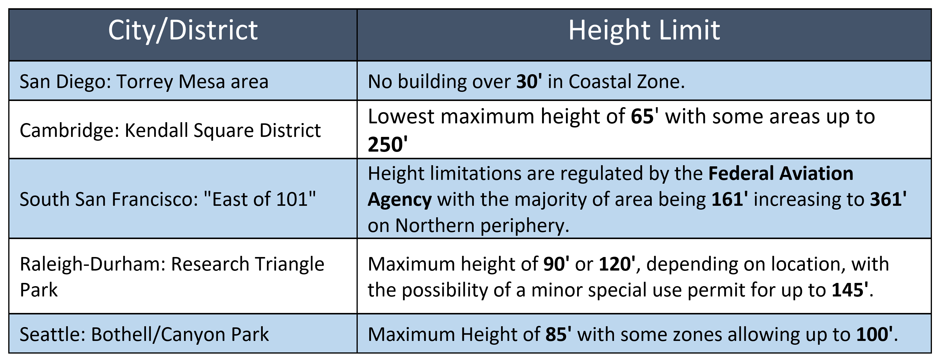
Lifting the height limit on the Torrey Mesa would remove a self-imposed handicap to San Diego’s biotech sector, and align it with other successful biotech hubs.
The Nobel Campus Transit Village currently holds commercial and residential uses. It has great potential for mixed-use development, but it is also within the 30-foot coastal height limit overlay zone. This neighborhood would benefit from additional height to unlock mixed-use and residential development.
Housing developments within the coastal height limit overlay zone can likely build higher than 30 feet, despite San Diego’s local rules. The California Department of Housing and Community Development (HCD) has opined in that California’s Density Bonus Law allows a development that includes deed-restricted affordable residential units to pierce San Diego’s 30-foot coastal height limit. While Circulate agrees with HCD’s analysis, it has not been clearly tested in the courts.[42]
One project in San Diego is already using the Density Bonus Law to pierce the coastal height limit overlay. San Diego Community Housing Corporation proposed a 60-unit, 60-foot-high residential building within the coastal height limit overlay zone using Density Bonus Law.[43] That project will serve low- and very low-income households, transitional aged youth, and homeless veterans.[44]
Density Bonus Law also allows mixed-use developments to pierce local height limits, though negotiations over incentives may be more complicated. A court is likely to agree with HCD that Density Bonus Law allows housing developments to pierce local height limits. Still, if voters removed that local height limit, it would remove any ambiguity in the law, and streamline more housing construction.
It is unlikely that any current state law would allow commercial or industrial development without a housing component to pierce the coastal height limit overlay. These developments would require a ballot measure to lift portions of the coastal height limit. Voter support for eliminating the height limit in the Midway District in 2020 and 2022[45] is a strong indication that San Diego voters are willing to eliminate height limits where there is no concern about blocking coastal views.
Bicycle lockers at the Balboa Avenue Trolley Station

Bicycle, Pedestrian, and Bus Corridors
The Mid-Coast has multiple stops in the University Community Plan area, however many of those stops do not provide easy access to attractive destinations. Access to the Trolley is hindered by a lack of safe and efficient access on a bicycle, on foot, and by bus. Adding protected bicycle lanes, transit-priority lanes, and improved pedestrian facilities would improve access to the Mid-Coast, and drive ridership on the Trolley. Making the most of the Mid-Coast means enhancing these connections.
Community planning documents contain more than just land use rules. They also include street networks, and future infrastructure projects. The update to the University Community Plan is an opportunity for San Diego to reimagine its surface street network in that area. The City, MTS, and SANDAG can also go above and beyond what is included in any community plan, and create additional treatments to streets to facilitate transit or to improve safety.
The City should retrofit streets in the University Community Plan area to make them safer for all road users, and particularly for pedestrians and bicyclists. Last year, 294 people were killed in traffic collisions in San Diego County, many of whom were bicyclists or pedestrians.[46] This loss of life is unacceptable and preventable. After an advocacy campaign launched by Circulate San Diego,[47] the City of San Diego committed to Vision Zero, a campaign to end traffic fatalities and serious injuries.[48] The City should make good on its Vision Zero commitments by making sure infrastructure around the Mid-Coast creates safety for all road users.
Bus riders at a SuperLoop stop

Dedicated lanes can keep buses and other shared vehicles out of traffic.
Many destinations in the University Community Plan area are too far from a Mid-Coast station to be convenient for pedestrians. Feeder buses are an important tool for creating access to higher-volume transit investments like a Trolley.
The University Community Plan should include the creation of dedicated lanes for shared vehicles, which will allow more people to use a quick bus ride to access the Mid-Coast. These lanes could be implemented quickly and cheaply. The two and a half-mile long El Cajon Boulevard dedicated bus-only lane cost only $100,000 to implement, and was completed in less than a year.[49] Transit agencies that implement basic dedicated bus-only lanes can deliver 25 percent faster commute times.[50]
Where bus-only lanes are not viable, HOV-3 lanes can be a good intermediate step. HOV-3 lanes allow any vehicle with at least three passengers to use the lane, similar to the existing freeway HOV lanes. HOV-3 lanes can also be a politically viable intermediate solution, to facilitate faster transit travel, without eliminating lanes entirely for car travel. Those lanes can later be converted to bus-only lanes when transit ridership increases.
Bus-only lanes would significantly speed up bus service for existing bus routes like Routes 201 and 202, which together make up the existing SuperLoop. These routes are among the highest performing MTS routes. These lanes can also be used by emergency vehicles to speed up response times. Employer sponsored shuttles and U.C. San Diego shuttles could also use these lanes.
Painted bus-only lanes are an extremely cost-efficient way of improving transit service that can be implemented quickly.[51] Other street improvements, including in-lane bus stops, near level boarding, transit signal priority, and improved bus stops can be included when the City undertakes the major street improvements contemplated in the Community Plan Update. Circulate San Diego’s recent report, “Fast Bus!,” contains more recommendations for improving bus service.[52]
Existing Bus Routes

Proposed Transit-Priority Lanes

Protected bicycle lanes save lives and make connections.
Planners generally consider a transit station to be easily accessible for pedestrians who can travel a half-mile to access a station. Station access by bicycle is substantially larger, usually considered a two-mile ride. The University Community Plan update should include infrastructure projects to create safer and more comfortable bicycle access to Mid-Coast stations. This will substantially increase the areas that have easy access to the Trolley.
Currently, riding a bicycle through the University Community Plan area is a scary proposition. High-speed arterials frequently have four or six lanes, with traffic that moves at 50 miles per hour or more. Bicyclists on these streets have only the protection offered by sharrows or narrow, unprotected bicycle lanes. Often these bicycle lanes disappear as they come to an intersection.
The danger of bicycling on these roads is very real. A person struck by driver at 40 miles per hour has an 80 percent chance of death or serious injury.[53] The recent deaths of Laura Shinn and John Sepulveda on Pershing Drive,[54] and Matt Keenan on Camino del Rio South[55] are stark reminders of the dangers created by high speed roads with inadequate protection for bicyclists.
According to the Bicycle Facility Selection Tool contained in SANDAG’s adopted 2021 Regional Plan, any road with a speed limit greater than 30 miles per hour should have a protected bikeway.[56] Following this guideline around the Mid-Coast will save lives and make important connections.
The University Community Plan should include separated, protected bicycle lanes or bicycle paths[57] on all of the major arteries in the area, including Genesee Avenue, La Jolla Village Drive, Nobel Drive, Sorrento Valley Road, and others.
U.C. San Diego’s efforts are a great example of how to achieve a safe bicycle network. The University plans to construct protected bicycle lanes along Voigt Drive between Genesee Avenue and Matthews Lane, where it will connect with an existing separated bicycle lane. It will also connect to the Voigt Drive station of the Mid-Coast, connecting bicyclists to transit.[58]
A separated bicycle facility at U.C. San Diego

The City of San Diego has also shown recently that it is able to deploy “quick-build” bicycle networks, in advance of more permanent protected bikeways.[59] These kinds of temporary improvements should be made in the near-term, even as planners and engineers prepare for more expensive and permanent improvements in the future.
Existing Bicycle Network

Proposed Bicycle Network

Improved pedestrian facilities create vibrancy and access.
Conditions for pedestrians near the Mid-Coast stations are currently better than conditions for bicyclists, but still need improvement. Good pedestrian facilities build connections to the Trolley. Pedestrian-oriented streets also encourage business activity and are more financially productive.[60]
There are some good pedestrian features in the University Community Plan area. Most streets have sidewalks, and many of them have a grassy buffer. Major crossings have crosswalks and most have countdown timers and audible pedestrian signals.
Circulate San Diego’s team of in-house planners conducted a mobility assessment around the Executive Drive Mid-Coast station, and found several deficiencies for pedestrian access. Sidewalks are generally narrow, unshaded, and lack pedestrian-scale lighting. Wide streets mean long pedestrian crossings.
Utility boxes, light posts, and other obstructions sometimes result in sidewalks that have a clear width of less than 36 inches, meaning that they do not comply with the American Disabilities Act and people using mobility devices such as wheelchairs may not be able to pass.[61] Many sidewalks also fail to comply with current pedestrian and accessibility design standards contained in the City of San Diego’s Street Design Manual. That document requires an unobstructed sidewalk width of five feet, with a possible exception for a three and a half foot width.[62]
The City of San Diego should conduct similar mobility audits around every Mid-Coast station, to inform the development of the University Community Plan, as well as other future policy decisions.
Depending on the conditions around each station, improvements for pedestrian and accessibility issues may include:
- Improved tree canopies,
- Safe mid-block crossings,
- Curb extensions,
- Wayfinding signage,
- Truncated domes for ADA access, where they are missing,
- Audible pedestrian signals, where they are missing.
Executive Drive Station - Map of Existing Bicycle and Pedesrian Infrastructure

Executive Drive Station - Map of Bicycle and Pedestrian Infrastructure Recommendations

Executive Drive Station - Map of Mobility Infrastructure Recommendations

Executive Drive Station - Infrastructure Recommendations

Circulate planning staff and volunteers perform a mobility assessment around Executive Drive Trolley station

Interior pathways allow pedestrians to cut through long blocks.
The University Community Plan area is composed of many large blocks that make it difficult for pedestrians to efficiently reach their destinations. If a pedestrian has to walk all the way around a block, a quarter-mile walk can easily turn into a half-mile walk.
Interior pedestrian pathways allow efficiency. Pedestrian pathways should be routed in ways that allow efficient access across large blocks, without winding detours. These interior walkways can be activated with park-like amenities, restaurants, and retail, creating a vibrant, mixed-use experience.
Because the City does not own these blocks, it is difficult to achieve these interior pathways. The Planning Department should incentivize developers that build public pedestrian and bicycle pathways that cut through long blocks. The City could offer reduced developer fees and TDM credit to developers that do so.
The City can also request or incentivize property owners to allow the public to use existing interior pedestrian pathways. This might be accomplished by allowing the change of use on an existing property in exchange for concessions on development standards on a new project with the same owner.
This is an example of a commercial property with an interior pathway that is not open to the public

Corridors outside of the University Community Plan area also drive ridership on the Mid-Coast.
While improvements in the immediate area around the Mid-Coast Trolley are essential, there is more yet to do to make the most of the Mid-Coast. Transit riders coming to and from destinations outside of the University Community Plan area also need transit-only lanes and safe bicycle and pedestrian infrastructure. This can be accomplished through several means.
SANDAG has several bus rapid transit projects in its adopted 2021 Regional Plan.[63] These projects plan to use existing funds, but their details have not been decided. This money can be used to create bus-only lanes, and to incorporate bicycle and pedestrian facilities for future bus enhancements that feed into the Mid-Coast.[64]
MTS, SANDAG, or the City of San Diego can take the lead on creating Safe Routes to Transit plans to identify gaps, prepare designs, and to fund solutions. These plans should not merely sit on a shelf, but should actually be implemented.
These agencies can also fund education and encouragement activities for bicycling, walking, and taking transit. Safe Routes to Transit and education and encouragement could be funded with Caltrans ATP grants, or from other funding sources.
MTS buses at the Balboa Avenue Trolley Station

Enhanced Transit Service
Building a new rail line like the Mid-Coast is an expensive, time consuming project. In contrast, improved transit service frequency can be implemented quickly and relatively cheaply. MTS already conducted a feeder bus study, which resulted in changes to bus routes to take advantage of the new Mid-Coast.[65] Having built the Mid-Coast and updated bus routes, San Diego should make sure that Trolley service and feeder bus routes run frequently. MTS and SANDAG should continue to evaluate new feeder routes for the Mid-Coast, and increase frequencies on existing feeder routes.
Riders deserve improved frequencies.
MTS’s Feeder Bus Study included a survey of existing and potential riders.[66] Seventy percent of respondents identified frequency of feeder buses as very important, making it their top concern. When bus routes and the Trolley run frequently, riders can count on catching a ride when they need it, rather than planning their day around when the bus or Trolley will arrive. Improved frequencies also make transfers more efficient, and increase the reliability of the system. Circulate San Diego’s report, “Fast Bus!,” explains in more detail the benefits of frequency.[67]
SANDAG’s 2021 Regional Plan includes commitments to improve frequencies on many routes, and four new rapid bus routes through the University Community Plan area by 2035.[68] However, resources for these routes are threated by SANDAG’s funding shortfalls.[69] SANDAG should prioritize bus rapid transit and transit frequency improvements when managing their limited resources.
Although there is funding planned for improving many routes, there is no new funding for Routes 201 and 202—also known as the SuperLoop. These are among the highest performing routes in the MTS system, and are prime candidates for bus-only lanes and for other upgrades featured in Circulate’s “Fast Bus!” report.[70] In particular, the SuperLoop often has large lines of people waiting to board. All-door boarding on high usage routes like the SuperLoop would make service faster and more reliable.
The SuperLoop often has many people waiting to board

Blue Line frequencies along the Mid-Coast should be improved to every seven and a half minutes during peak periods. The SANDAG 2021 Regional Plan includes goals to achieve this frequency by 2035. That timeline should be moved up as soon as possible. Ridership on the Blue Line has already risen by almost 50 percent since the opening of the Mid-Coast.[71] In addition, the southern portion of the Blue Line already runs at seven and a half minute intervals. Bringing the full line up to seven and a half minute intervals would generate more ridership and bring the entire line onto the same schedule.
When designing a transit network, planners must consider the ridership-coverage trade off.[72] Transit agencies that prioritize ridership focus on areas where direct routes can serve large numbers of people. Transit agencies that prioritize coverage focus on making sure that every resident has access to some level of transit, even if it is not high-quality service.
While MTS should keep a balance between these objectives, it should prioritize higher ridership. Ridership serves more people, delivers better service, and delivers more climate benefits.[73]
Improving frequencies of feeder buses and the Blue Line will achieve higher ridership. In addition, improved transit service will benefit the entire network as riders travel between the University Community Plan area and other parts of the region.
Enhanced bus shelters will make riders feel welcome.
Currently, feeder bus routes have a wide variety of quality for bus shelters. SuperLoop stations have shelters with ample shade and seating, while other routes have no shelter at all. Bus shelters improve ridership by giving riders a comfortable place to wait for the bus to arrive.
The City, SANDAG, and MTS should look for ways to fund improved bus shelters. These shelters should focus on cost-efficiently delivering the basic needs of seats and shelter from sun, wind, and rain. Cost efficiency will ensure that the greatest number of shelters will be possible to install. SuperLoop shelters were designed to cost at most $225,000 per station.[74] In contrast, in 2016, MTS began installing 600 bus shelters and 1,800 benches at a cost of $7.9 million for manufacturing and installation.[75] The average cost per shelter or bench for this effort was $3,292.[76] For the cost of one SuperLoop shelter, SANDAG could have purchased approximately 68 benches or shelters.[77]
The SuperLoop has large, comfortable bus shelters

Some bus shelters have no shelter, lighting, or seating

Public agencies should partner with providers of private shuttles.
Private shuttles are an important piece of the University Community Plan area’s transportation network, providing connections to the Trolley, the Coaster, and to other neighborhood amenities. These shuttles should at least initially be allowed to access transit-priority or HOV-3 lanes, because they offer an efficient transportation solution with lower greenhouse gas impacts.
These shuttles are not accessible to the public, and may be duplicative of other private shuttles and public transit routes in the area. Along routes where private shuttles are successful, MTS and SANDAG should evaluate whether there is enough demand to expand bus service to replace these private shuttles. This would avoid duplicative shuttles, reduce costs to employers, and allow public access.
Employer sponsored shuttles are often part of a developer’s transportation demand management commitments to reduce car reliance. If those commitments need to be maintained, they could be transitioned into financial contributions to MTS to support the new or enhanced public transit service.
Surplus Government Land
MTS, SANDAG, and the City of San Diego, as well as other government entities, all own properties near Mid-Coast stations. These properties should be evaluated for potential redevelopment for housing and mixed-use projects.
Recent reforms to California’s Surplus Land Act also mean that any redevelopment of surplus government property will mean an opportunity for affordable housing developers to have priority.[78] This is likely to mean new opportunities to build 100 percent affordable projects near our region’s valuable transit investments.
Circulate San Diego’s 2018 report, Real Opportunity, highlighted the potential of redeveloping underutilized MTS parking lots into affordable homes.[79] The report successfully pushed MTS to update its joint-development policy. The new policy is already resulting in the development of several properties,[80] including the parking lot at the Grantville Station, which will include one building with 124 homes affordable to very low-income families, and another with 250 student apartments.[81]
The same opportunities exist for MTS parking lots along the southern half of the Mid-Coast. New data from Circulate San Diego shows low parking utilization at Tecolote Road Station, moderate utilization at Balboa Ave Station, significant utilization at Nobel Drive Station, and no usage at UTC Station.[82] UTC and Nobel Drive are parking garages that are ill-suited for redevelopment, but MTS should evaluate development options for the other parking lots under their updated joint-development policy.
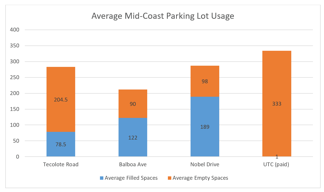
When evaluating properties for redevelopment, MTS should require no more parking that is currently being used, even when that is significantly less than the amount of currently available parking.[83]
SANDAG is in a similar position. SANDAG sought to obtain a site to provide a parking lot at the Clairemont Drive Mid-Coast Station, but instead negotiated with the property owner and obtained a requirement that the developer build 150 parking stalls as part of a coming mixed-use development.[84] In 2022, the property was sold to another developer, with 150 parking spaces still required.[85] In light of low utilization of parking lots at nearby stations, SANDAG should consider reducing parking requirements for this site.
Parking lots are not the only government-owned sites with potential for redevelopment. The City of San Diego’s Rose Canyon City Operations Station is another a prime opportunity. It is located across the street from the Balboa Avenue Mid-Coast Station, and is currently an industrial use very near to residential and commercial uses. If this facility were relocated, it would open up a significant property for residential and transit-oriented development. There is also an existing pedestrian bridge from the Balboa Avenue Station across Balboa Avenue that could easily be connected to a new development at this location.
All government agencies with properties near the Mid-Coast stations should work to identify opportunities for development. These opportunities do not have to be large lots or immediately adjacent to the station to be workable. Smaller properties can support local businesses because they are more likely to be workable for smaller local developers.
Low parking utilization at the Tecolote Road Station

Improved Mid-Coast Stations
Mid-Coast stations should be updated to better integrate into their surrounding neighborhoods. That means improving the pedestrian and bicycling experience, improving disability accessibility, improving connections to the bus, and ensuring that future developments incorporate the Trolley as an asset rather than an afterthought.
Stations should also receive other upgrades, including:
- Station attendants to assist passengers and maintain a clean and inviting environment,
- Bathrooms,
- ADA access features,
- Lighting,
- Safe storage for privately-owned bicycles,
- Space to accommodate bicycle-share and other micro-mobility services, and
- Space activations such as retail stores, coffee carts, and food trucks.
New development near Trolley stops should be oriented towards the station, to create a welcoming environment for transit riders, and encourage ridership. Currently, many stops are located at the back of parking lots. This transit-as-an-afterthought approach inconveniences transit riders by putting them farther away from their destinations. It often forces them to walk through unpleasant and dangerous parking lots to reach their destination. The Nobel Drive station is an example of this kind of unfortunate design. In contrast, the Riverwalk project, which is currently under construction, will incorporate its new Trolley station into the project design. Riverwalk received Circulate San Diego’s Mobility Certification for transit-oriented smart growth projects.[86]
The Riverwalk Station will be incorporated into the surrounding neighborhood

The Nobel Drive Station is located at the back of a parking lot

Redevelopment of MTS parking lots should be a priority. Where MTS does keep transit parking, MTS should charge for its use. Free parking encourages car travel, which results in more air pollution, greenhouse gas emissions, traffic congestion, and sprawl.[87] Charging for parking generates revenue that MTS can use for improved transit operations and station safety.
Pricing of MTS parking lots should be flexible and demand-based, with different prices for commutes, sports game days, conventions, concerts, and other events. MTS parking lots should also include electric vehicle charging stations where those are absent.
To its credit, SANDAG’s mobility hub strategy for Mid-Coast stations contains many of these recommendations.[88] The strategy includes improved pedestrian pathways, bikeways, and transit-only lanes. When SANDAG implements these strategies, it should be sure to focus on these tried-and-true strategies, rather than more speculative elements of their plan. Autonomous vehicles and other futuristic technologies have shown far more hype than substance. Public investments should prioritize proven strategies over vaporware that have not delivered on promises.[89]
City-Wide Land Use Policies
Policy decisions related to a single neighborhood or a single parcel often attract fierce opposition. In contrast, city-wide policies tend to face less local opposition, and attract more support from influential regional players. Land-use decisions that are made on a city-wide basis have a broader impact, and create the right political conditions for smart growth policy.[90]
In the case of the University Community Plan update, a common refrain from anti-housing activists is “Why is this only happening in our neighborhood?” While the analysis is incorrect—the City of San Diego is in the midst of several community plan updates and is planning to update many more—it does highlight the usefulness of the city-wide approach.
The City of San Diego can help implement smart growth around the Mid-Coast not just through the University Community Plan, but also through city-wide policies. These city-wide policies can help the University Community Plan reach its full potential. The City should update its transportation demand management (TDM) checklist with new options to reduce vehicle miles traveled (VMT), retool its Floor Area Ratio (FAR) purchase program, enhance its moderate-income density bonus, allow the affordable homes bonus program in all multifamily zones, encourage the development of homes and mixed-use constructions on outdated shopping centers, and allow townhomes in single family neighborhoods near transit.
Flexible transportation demand management requirements would allow developers to innovate and be effective.
TDM policies are requirements placed on developers to include features within their projects that reduce VMTs.[91] These features reduce traffic, air pollution, and greenhouse gas emissions by encouraging modes of travel other than a single occupant car.[92]
Currently, the City of San Diego awards points for the following TDM measures for all developments: bicycle maintenance facilities, bicycle parking, bikeshares, bicycle lanes, passenger loading zones, car share, carpool parking, micro-mobility charging stations and parking, provision of the minimum number of parking spaces, intersection improvements, sidewalk improvements, multi-modal information kiosks, and transit infrastructure improvements.[93]
Residential projects near transit can also receive credit for on-site childcare facilities, delivery storage amenities, health and wellness amenities, co-working space for telecommuters, shuttle bus programs, charging separately for parking, and transit subsidies.[94]
Regulations should be updated so that non-residential projects can get credit for more of the measures that residential projects get credit for, including:
- On-site childcare,
- Telecommute incentives,
- Employer-sponsored transit passes,
- Employer-sponsored shuttles, and
- Charging separately for parking.
We also recommend giving credit for employer or landlord sponsored education and encouragement activities for bicycling, walking, and transit. San Jose and San Francisco currently allow TDM credit for these kinds of programs.[95] These programs can be fun and informative for employees or residents, and can be paired with social events like happy hours, park days, or sporting events. Circulate San Diego’s “Transit for Fun” program is a good example of how an employer can achieve this.[96]
San Diego should also allow residential projects to get TDM credit for including deed-restricted affordable homes in a project. Lower-income residents typically own fewer cars and create fewer VMTs.[97] San Francisco[98] and San Jose[99] already allow a TDM credit for affordable housing.
San Diego should follow San Jose’s lead and provide TDM credit to projects that include density and mixed-use aspects. San Jose allows credit for projects that are denser than the existing conditions in the surrounding area, and for projects that “increase the amount of space dedicated to mixed employment and high-density residential uses in the area surrounding the project.”[100]
Finally, San Diego should allow developers to innovate by requesting TDM credit for off-menu improvements and programs, so long as the developer can show that a measure would reduce VMT at least as much as on-menu measures.
Bonus programs for non-residential developments can give incentives and fund affordable housing.
San Diego’s Employee Housing Incentive Program allows non-residential developers to receive incentives by paying the Employee Housing Incentive Program Fee.[101] The program is similar to a recommendation of Circulate San Diego’s 2017 report, “Transit Oriented Development.”[102] It functions in a manner similar to San Diego’s Affordable Homes Bonus Program, in that it allows trading affordable housing to gain added development capacity (in the form of more FAR), but for commercial developments rather than residential developments. Because the beneficiaries of the program are commercial developments, the developer is not able to construct on-site affordable homes, and instead pays a fee which is put into San Diego’s Affordable Housing Fund.[103]
In order to be eligible, a development must be within a transit priority area. Eligible uses include retail sales, commercial services, office, light manufacturing, and research and development. FAR may not be increased by more than 1.5.[104] The Employee Housing Incentive Program Fee has been set at $475,000 per development incentive.[105]
The City should explore allowing a greater FAR bonus than 1.5, for an additional fee. In addition, the City should consider setting a fee that scales with the amount of developable square footage added. Currently, smaller projects must pay the same fee as larger projects, even though the increased FAR yields far less square footage. Finally, the City should ensure that commercial developments get linkage fee credit for using the program.
Enhancing the Middle-Income Bonus Program will result in more homes.
San Diego’s Affordable Homes Bonus Program (AHBP) allows up to a 50 percent density bonus if 15 percent of a project’s base density is set aside for very low-income families. The success of this program was detailed in Circulate San Diego’s report, “Home Run for Homes.”[106] The program is a prime example of San Diego’s leadership as a pro-housing city.
In addition to the AHBP, San Diego allows a developer that maximizes its 15 percent AHBP affordable production, an additional Middle-Income Bonus. The Middle-Income Bonus allows an additional 25 percent density bonus if an additional 10 percent of the base density is set aside as affordable to moderate income households.[107] To Circulate San Diego’s knowledge, no developer has ever used this bonus.
San Diego should continue its bonus program leadership by revamping its Middle-Income bonus program to allow an additional 50 percent density bonus if a developer includes an additional 15 percent of base density as deed-restricted for moderate-income households. Like the current program, this enhancement should only be available if a developer maxes out the production of 15 percent affordable units in the original AHBP. This would create an additional incentive to produce low- or very low-income homes, while also creating more middle-income and market-rate housing.
The AHBP can be updated to benefit all multifamily areas.
San Diego has another opportunity to lead on bonus programs. Currently, the highly successful AHBP is only allowed where the underlying zoning is for five or more units. It is also limited to projects of five units or more. Allowing AHBP for projects less than five units, in areas zoned for two or more units, would open the possibility for more “missing middle” housing, which would fill a gap between single-family and higher density multi-family housing. This type of housing generally has a lower construction cost, which would result in more affordability.
This reform would also support small businesses by opening up a product type that works for small-scale developers.
State law implementation will allow housing and mixed-use development on outdated shopping centers.
With the signing of SB 6 and AB 2011 this year, underused commercial sites have the potential to become new housing developments. Both bills allow new housing on commercial sites that meet certain labor and affordability standards. Both allow local implementing ordinances that are exempt from CEQA.
The City should adopt implementing ordinances for both SB 6 and AB 2011 that ensure the greatest flexibility and development capacity, to generate as much housing as possible. Many of these under-utilized commercial sites are adjacent to the Mid-Coast stations or to other transit lines, and are excellent opportunities for transit-oriented development. Implementing these policies will create more affordable homes, while ensuring high-quality career paths in the construction industry.
Townhomes can deliver ownership opportunities in single family neighborhoods near transit.
While development of large apartment complexes is an important piece of addressing San Diego’s housing shortage, many San Diegans are unable to achieve their dream of owning a home. Townhome zoning would provide ownership opportunities at prices that moderate-income San Diegans can afford. Allowing townhomes near transit would meet the housing crisis while promoting clean transportation.
In February of 2022, the Planning Department proposed as a part of the University Community Plan update, to allow townhomes in some single-family areas of South University.[108] The Planning Department reasoned that this would create ownership opportunities for middle-income families. Moreover, the level of density was already allowed because of SB 9.
SB 9 allows multiple dwellings on parcels zoned for single family homes, and includes requirements regarding lot sizes, owner occupancy, and demolition of existing structures.[109] Allowing townhome density at the same level as SB 9 would give developers greater design flexibility to build more attractive and diverse projects. This would result in more projects being built.
The initial proposal for town homes in the South of University neighborhood has subsequently been removed from any of the City’s proposals for the University Community Plan area.
The City should not give up on this important idea. Instead of allowing this kind of development only in South University, or through the University Community Plan update process, the City can adopt a policy to allow this product type city-wide. With a city-wide policy, possibly limited to proximity to transit, townhome zoning would unlock new development potential while distributing new capacity fairly across all neighborhoods.
Townhome zoning would allow greater flexibilty than SB 9 rules

Other Land Use Updates
While this report focuses on improvements to the University Community Plan and to locations near the Mid-Coast, the concepts are applicable beyond these areas. The Clairemont Mesa Community Plan area is currently engaged in a community plan update. That plan update should similarly include increased capacity for homes and businesses, especially directly adjacent to new Trolley stops, and along feeder bus routes.
Lessons extend beyond just the City of San Diego. Other cities along the southern part of the Blue Line like National City, Chula Vista, and Tijuana should also contemplate updates to their land uses to allow more of their residents to access the new Mid-Coast.
Increasing development capacity and improving bicycle and pedestrian facilities near public transportation is a recipe for economic growth, environmental sustainability, and a more equitable region.
Conclusion
The San Diego region has an historic opportunity presented by the Mid-Coast. After investing $2.2 billion dollars, the region should make sure that the Trolley is well connected to new jobs and homes, with good bus, bicycle, and pedestrian infrastructure. In order to grow our economy, reduce our greenhouse gas emissions, and meet the challenges of our housing crisis, San Diego needs more growth in the University Community Plan area, and improved transportation options connecting to the Trolley.
Making the right investments, and the right policy choices will allow San Diego to truly make the most of the Mid-Coast.
Acknowledgements

Jesse is policy counsel for Circulate San Diego, where he researches and advocates for land use and transportation policy solutions for a more affordable and sustainable San Diego.

Colin Parent is Executive Director and General Counsel at Circulate San Diego. He has authored a number of reports and academic publications detailing how local land use and transportation policy can be improved to advance equity, promote economic development, and to address climate change. Colin is also an elected member of the City Council of La Mesa, California.
About Circulate San Diego
Circulate San Diego is a nonprofit whose mission is to create excellent mobility choices and vibrant, healthy neighborhoods. Circulate promotes public transit, safe streets, and sustainable growth. Circulate has successfully led campaigns to transform empty parking lots into affordable homes, to implement free transfers for transit riders, and for local jurisdictions to adopt Vision Zero to end traffic fatalities and serious injuries. For more information, visit www.circulatesd.org.
Special Thanks
The content of this report was informed by the expertise and feedback from an advisory committee, who we thank for their assistance. The advisory committee included Matt Adams, Carey Algaze, Ari Astalos, Lydia Bartell, Craig Benedetto, Tanner Blackman, Ben Boyce, Kathy Breedlove, Harry Bubbins, Nancy Chase, Ryan Clumpner, Melanie Cohn, Katie Crist, David Dekozan, Dan Feder, Bethany Garretson, Mike Hansen, Angeli Hoyos, Lauren Jumanan, Ted Kagan, Josh Kavanagh, Kris Kopensky, James Lawson, Aidan Lin, Jason Moorehead, Josh Moshy, Laura Nunn, Will Rhatigan, Sherry Ryan, Stephanie Saathoff, Ryan Sullivan, and Alex Wenzel.
Thank you to our interns, Gianna Ceccarelli, Courtney Brown, Emilie Millard, and Matthew Goodman, for their valuable research and field work.
Special thanks to Circulate’s Planning team members Dara Braitman, Carlisle Dockery, Octavio Garcia, and Morgen Ruby for assisting in designing the report and maps, and leading our walk audit of the Executive DriveMid-Coast Station.
The cover photo was commissioned by artist Walt Haim.
Sponsors
We are grateful for the financial support from our sponsors